Lions Rump
Headland in Antarctica
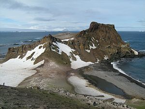
Lions Rump is a conspicuous headland 2 km (1.2 mi) north-northeast of Low Head, forming the west side of the entrance to King George Bay, on King George Island, in the South Shetland Islands of Antarctica. It was charted and given its descriptive name in 1937 by Discovery Investigations personnel on the Discovery II.[1] Chopin Ridge runs between Lions Rump and Low Head. The rock feature known as "Martello Tower" lies 4 km (2.5 mi) to the north-northwest.
Important Bird Area
The headland has been identified as an Important Bird Area (IBA) by BirdLife International because it supports a large breeding colony of Adélie penguins, with about 12,000 pairs recorded in 1980. Other birds nesting at the site in smaller numbers include gentoo and chinstrap penguins, southern giant petrels, Cape petrels, Wilson's and black-bellied storm petrels, snowy sheathbills, south polar and brown skuas, kelp gulls and Antarctic terns. Southern elephant seals, Antarctic fur seals and Weddell seals breed on the beaches. The boundary of the 149 ha (370-acre) IBA is defined by the boundary of ASPA 151, designated for the protection of the ecological values of the area, including the lichens, vascular plants and birds, and of representative examples of maritime Antarctic habitats.[2]
References
- ^ "Lions Rump". Geographic Names Information System. United States Geological Survey, United States Department of the Interior. Retrieved 2013-06-19.
- ^ "Lions Rump, King George Island". BirdLife data zone: Important Bird Areas. BirdLife International. 2013. Retrieved 2013-01-09.
![]() This article incorporates public domain material from "Lions Rump". Geographic Names Information System. United States Geological Survey.
This article incorporates public domain material from "Lions Rump". Geographic Names Information System. United States Geological Survey.
- v
- t
- e
- Admiralty Bay
- Ardley Island
- Byers Peninsula
- Cape Shirreff
- Collins Point
- Coppermine Peninsula
- Crater Lake
- Deception Island
- Discovery Bay
- Fildes Peninsula
- Harmony Point
- Kroner Lake
- Lions Rump
- Mount Pond
- Narębski Point
- Pendulum Cove
- Port Foster
- Potter Peninsula
- Ronald Hill
- San Telmo Island
- South East Point
- Stonethrow Ridge
- Suffield Point
- Telefon Bay
62°8′S 58°7′W / 62.133°S 58.117°W / -62.133; -58.117
 | This King George Island (South Shetland Islands) location article is a stub. You can help Wikipedia by expanding it. |
- v
- t
- e


