Mertz Glacier
Glacier of Antarctica
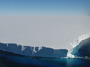
Mertz Glacier (67°30′S 144°45′E / 67.500°S 144.750°E / -67.500; 144.750) is a heavily crevassed glacier in George V Coast of East Antarctica. It is the source of a glacial prominence that historically has extended northward into the Southern Ocean, the Mertz Glacial Tongue. It is named in honor of the Swiss explorer Xavier Mertz.
The Mertz-Ninnis Valley (67°25′S 146°0′E / 67.417°S 146.000°E / -67.417; 146.000 (Mertz-Ninnis Valley)) is an undersea valley named in association with the Mertz Glacier and the Ninnis Glacier.
Geography

Mertz Glacier is about 45 miles (72 km) long and averaging 20 miles (32 km) wide. It reaches the sea at the head of a 60 km fjord where it continues as a large glacier tongue out between Cape De la Motte/Buchanan Bay on the West, and Cape Hurley/Fisher Bay on the east, into the Southern Ocean. The Mertz Glacier Tongue (67°10′S 145°30′E / 67.167°S 145.500°E / -67.167; 145.500 (Mertz Glacier Tongue)) is about 50 miles (80 km) long in total hence it protrudes about 20–25 km out into the Ocean. It is roughly 25 miles (40 km) wide. The Glacier delivers about 10 to 12 Gigatons of ice per year to the fjord and the Tongue advances at about 1 km per year down the fjord and out into the Ocean.
History
The glacier was discovered by the Australasian Antarctic Expedition (1911–14) under Douglas Mawson, who named it for Xavier Mertz, a member of the expedition who died on January 7, 1913, on the far-east sledge journey.[1] Mertz's body likely remains in the glacier that bears his name, a few miles closer to the Southern Ocean than when he was buried in the ice by Mawson.[2]
2010 calving

In February 2010 about half of the Mertz Glacier Tongue, a piece of ice about 78 kilometres (48 mi) long and 33–39 kilometres (21–24 mi) wide and protruding 100 kilometres (62 mi) out into the Southern Ocean, broke away from the main body of the Tongue.[3] The separation occurred around the 12 or 13 February along two existing rift lines on opposite sides of the Tongue.[4] The event was helped in part when the large Iceberg B-9B collided with it. Iceberg B-9B is a 97 kilometres (60 mi) long by 30 kilometres (19 mi) wide remnant of Iceberg B-9 which broke off the Ross Ice Shelf in 1987[5] and has recently ungrounded itself from Ninnis Bank to the east of the Tongue where it had been lodged for 18 years.
The newly formed iceberg has been named Iceberg C-28,[6] because it is the 28th substantial iceberg to have broken off the Antarctic ice shelf, in the quadrant that faces Australia, since 1976. The iceberg is 400 metres (1,300 ft) high, has a surface area of 2,545 square kilometres (983 sq mi)[7] and weights in at about 860 billion tonnes. According to Australian glaciologist Neal Young, such an event occurs once in 50 to 100 years.[8] As the Tongue advances at 1 km per year this new iceberg represents about 70 years of glacier advance. Within 2 weeks the Mertz Iceberg rotated about the point of impact with B9-B and lay parallel with the coastline.[9] The iceberg drifted westwards after the collision and in April 2010 hit a submerged peak which caused it to break into two pieces.[10][11]
The flow of icebergs from the calved glacier tongue has reduced the effectiveness of the polynya west of Mertz Glacier that acted as one of Antarctica's major areas for the formation of dense Antarctic Bottom Water. The calving could affect future thermohaline circulation around Antarctica.[12][13]
Important Bird Area
A 641 ha site on fast ice near the northern, or terminal, edge of the glacier toe has been designated an Important Bird Area (IBA) by BirdLife International because it supports a colony of emperor penguins. Since its original identification in 2009, and the split of the tongue in 2010, the colony split into two sub-colonies about 20 km apart, with a ground census estimating some 5,100 breeding pairs in the western colony and 2,300 breeding pairs in the eastern.[14]
See also
- Ice stream
- List of glaciers in the Antarctic
- List of Antarctic ice streams
- Petermann Glacier
- Wilkins Sound
References
- ^ "Mertz Glacier". Geographic Names Information System. United States Geological Survey, United States Department of the Interior. Retrieved 2013-09-20.
- ^ ABC Local Radio item
- ^ "Massive iceberg calves from the Mertz Glacier". Australian Antarctic Division. 2010-02-26. Archived from the original on 2017-07-21. (Detailed press release).
- ^ Antarctic Climate and Ecosystems Cooperative Research Centre report Archived 2011-02-25 at the Wayback Machine
- ^ Prizborski, Paul (February 27, 2010). "Collision Calves Iceberg from Mertz Glacier Tongue, Antarctica". Earth Observatory. National Aeronautics and Space Administration. Retrieved 27 February 2010.
- ^ "National Ice Center press statement". Archived from the original on 2010-05-27. Retrieved 2010-08-09.
- ^ Darby, Andrew (February 27, 2010), "Iceberg as big as the ACT breaks away from Antarctic glacier", Sydney Morning Herald
- ^ Martel, Rags (26 February 2010), "Giant iceberg breaks from glacier", Channel 4.
- ^ European Space Agency Envisat radar images
- ^ Australian Antarctic Division News update
- ^ Latest National Ice Center pictures
- ^ "Loss of Antarctic ice 'tongue' could change seas". Climate Change on MSNBC.com. Reuters. January 31, 2011. Archived from the original on February 2, 2011. Retrieved 5 February 2011.
- ^ Fogarty, David (January 31, 2011). "Antarctic glacier mission seeks global climate clues". Reuters Africa. Archived from the original on August 20, 2012. Retrieved 5 February 2011.
- ^ "Mertz Glacier". BirdLife Data Zone. BirdLife International. 2015. Retrieved 17 November 2020.
External links
 This article incorporates public domain material from "Mertz Glacier". Geographic Names Information System. United States Geological Survey.
- v
- t
- e
Important Bird Areas of Antarctica
- Amanda Bay
- Bluff Island
- Boyd Island
- Caro Island
- Donskiye Islands
- Filla Island
- Gardner Island
- Hop Island
- Kazak Island
- Lucas Island
- Lugg Island
- Magnetic Island
- Rookery Lake
- Tryne Islands
- Turner Island
- Warriner Island
- Waterhouse Island
- West Ice Shelf
- Zolotov Island
- Arthurson Ridge
- Kartografov Island
- Mount Archer
- Sturge Island
- Adélie Cove
- Blue Glacier to Cape Chocolate
- Cape Adare
- Cape Main
- Cape Roget
- Cape Wadworth
- Cape Washington
- Cotter Cliffs
- Dailey Islands
- Depot Island
- Downshire Cliffs
- Duke of York Island
- Dunlop Island
- Edmonson Point
- Foyn Island
- Gregory Island
- Inexpressible Island
- Mandible Cirque
- Possession Islands
- Seabee Hook
- Brownson Islands
- Edwards Islands
- Hummer Point
- Lindsey Islands
- Maher Island
- Mathewson Point
- Mount Paterson
- Thurston Glacier
- Worley Point
- Ambush Bay
- Apéndice Island
- Armstrong Reef
- Avian Island
- Bates Island
- Brash Island
- Brown Bluff
- Cape Evensen
- Cape Wollaston
- Cierva Point
- Cockburn Island
- Cormorant Island
- Cuverville Island
- D'Urville Monument
- Danger Islands
- Devil Island
- Dion Islands
- Dodman Island
- Dream Island
- Duroch Islands
- Earle Island
- Eden Rocks
- Emperor Island
- Gerlache Island
- Ginger Islands
- Gourdin Island
- Guépratte Island
- Hope Bay
- Joubin Islands
- Lagotellerie Island
- Litchfield Island
- Madder Cliffs
- Midas Island
- Moss Islands
- Murray Island
- Paulet Island
- Pearl Rocks
- Penguin Point
- Petermann Island
- Pursuit Point
- Rosenthal Islands
- Ryder Bay Islands
- Snow Hill Island
- Stonington Island
- Trinity Island
- Tupinier Islands
- Uruguay Island
- Admiralty Bay
- Ardley Island
- Aspland Island
- Baily Head
- Barnard Point
- Byers Peninsula
- Cape Bowles
- Cape Garry
- Cape Hooker
- Cape Lookout
- Cape Melville
- Cape Shirreff
- Cape Wallace
- Chinstrap Cove
- Eadie Island
- East of Nelly Point
- Eastern Litwin Bay
- Escarpada Point
- False Round Point
- Fur Seal Point
- Gibbs Island
- Half Moon Island
- Harmony Point
- Heywood Island
- Jameson Point
- Kellick Island
- Lions Rump
- Milosz Point
- Mount Elder
- North Foreland
- O'Brien Island
- Owen Island
- Penguin Island
- Point Hennequin
- Point Wordie
- Potter Peninsula
- Pottinger Point
- Saddleback Point
- Seal Islands
- Stinker Point
- Sugarloaf Island
- Tartar Island
- Vapour Col
- Walker Point
- Yankee Harbour
- Atriceps Island
- Buchanan Point
- Cape Davidson
- Cape Hansen
- Cape Robertson
- Cape Whitson
- Cheal Point
- Christoffersen Island
- Eillium Island
- Ferguslie Peninsula
- Ferrier Peninsula
- Fraser Point
- Fredriksen Island
- Gibbon Bay
- Gosling Islands
- Graptolite Island
- Grey Island
- Inaccessible Islands
- Larsen Islands
- Matthews Island
- Michelsen Island
- Moe Island
- Moreton Point
- Pirie Peninsula
- Point Martin
- Return Point
- Robertson Islands
- Shingle Cove
- Signy Island
- Skilling Island
- Southern Powell Island
- Watson Peninsula
- Weddell Islands
Portals:
 Birds
Birds Water
Water Geography
 Earth sciences
 Weather


