Possession Islands
Islands of Antarctica
71°56′S 171°10′E / 71.933°S 171.167°E / -71.933; 171.167.Antarctica
The Possession Islands (71°56′S 171°10′E / 71.933°S 171.167°E / -71.933; 171.167) are a group of small islands and rocks extending over an area of about 7 nautical miles (13 km; 8.1 mi), lying in the western part of the Ross Sea, lying 5 nautical miles (9.3 km; 5.8 mi) south-east of Cape McCormick, in Victoria Land, Antarctica. The Possession Islands were named by Captain James Clark Ross, Royal Navy, in commemoration of the planting of the British flag here on January 12, 1841.[1]
Important Bird Area
A 276 ha (680 acres) site comprising the whole of Possession Island has been designated an Important Bird Area (IBA) by BirdLife International because it supports about 111,000 breeding pairs of Adélie penguins, based on ground counts made from 1981 to 2012. A significant south polar skua colony is also present on the island.[2]
Features
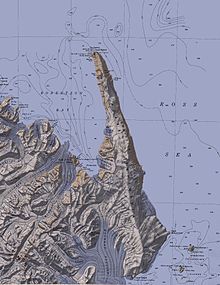
Named features, from south to north, are:
Heftye Island
71°59′S 171°06′E / 71.983°S 171.100°E / -71.983; 171.100. Small island which is the southernmost of the Possession Islands, lying east of the south end of the Adare Peninsula. Named by a Norwegian expedition of 1894-95, led by Bull and Kristensen, for Messrs. Thos, Joh. Heftye and Son of Christiania (now Oslo), shareholders in the expedition ship Antarctic.[3]
Bull Island
71°59′S 171°06′E / 71.983°S 171.100°E / -71.983; 171.100. Rocky island between Kemp Rock and Heftye Island. Mapped by United States Geological Survey (USGS) from surveys and United States Navy air photos, 1960–63. Named by United States Advisory Committee on Antarctic Names (US-ACAN) for Henrik Johan Bull who, with Captain Leonard Kristensen, explored this area in 1895 in the ship Antarctic and landed on the Possession Islands.[4]
Kemp Rock
71°58′S 171°06′E / 71.967°S 171.100°E / -71.967; 171.100. A large insular rock between Foyn Island and Bull Island. Mapped by USGS from surveys and United States Navy air photos, 1960-63. Named by US-ACAN for William R. Kemp, PHI, United States Navy, Photographer of Squadron VX-6 on the flight of January 18, 1958, at the time the Possession Islands and this feature were photographed.[5]
Foyn Island

71°56′S 171°04′E / 71.933°S 171.067°E / -71.933; 171.067. The second largest island in the Possession Islands, lying 4 nautical miles (7.4 km; 4.6 mi) southwest of Possession Island. Named by a Norwegian expedition of 1894-95, led by Bull and Kristensen, for Svend Foyn, primary financer of the expedition.[6]
St. Marie Peak
71°56′S 171°05′E / 71.933°S 171.083°E / -71.933; 171.083. A small peak, 100 metres (330 ft) high, at the north end of Foyn Island. Mapped by USGS from surveys and United States Navy air photos, 1958-63. Named by US-ACAN for Lieutenant Commander John W. St. Marie, United States Navy, co-pilot on the Squadron VX-6 flight of Jan. 18, 1958, at which time the Possession Islands and this feature were photographed.[7]
Favreau Pillar
71°57′S 171°07′E / 71.950°S 171.117°E / -71.950; 171.117. A pillar rock lying close east of Foyn Island. Mapped by USGS from surveys and United States Navy air photos, 1958-63. Named by US-ACAN for Robert D. Favreau, USMC, Navigator on the United States Navy Squadron VX-6 flight of Jan. 18, 1958, at the time this feature was photographed.[8]
Kristensen Rocks

71°55′S 171°11′E / 71.917°S 171.183°E / -71.917; 171.183. Twin rocks lying 1 nautical mile (1.9 km; 1.2 mi) south of Possession Island. Mapped by USGS from surveys and United States Navy air photos, 1960-63. Named by US-ACAN for Captain Leonard Kristensen who, with H.J. Bull in the ship Antarctic, explored the area and landed on the Possession Islands in 1895.[9]
Dickson Pillar
71°54′S 171°11′E / 71.900°S 171.183°E / -71.900; 171.183. A pillar rock lying close south of Possession Island. Mapped by USGS from surveys and United States Navy air photos, 1958-63. Named by US-ACAN for Paul B. Dickson, PHC, USN, Photographer of Squadron VX-6 on the flight of January 18, 1958, at the time this feature was photographed.[10]
Possession Island
71°52′S 171°12′E / 71.867°S 171.200°E / -71.867; 171.200. Rocky island nearly 2 nautical miles (3.7 km; 2.3 mi) long, which is the northernmost and largest of the Possession Islands. Discovered by a British expedition under James Clark Ross, 1839-43, and so named by him in commemoration of the planting of the British flag there on Jan. 12, 1841.[11]
Archer Peak
71°52′S 171°10′E / 71.867°S 171.167°E / -71.867; 171.167. Peak, 110 metres (360 ft) high, on the southwest extremity of Possession Island. Named by the British Antarctic Expedition, 1898-1900, presumably for A. Archer, Esq., of Australia, mentioned in the preface to Borchgrevink's "First on the Antarctic Continent", or for Colin Archer who designed Carsten Borchgrevink's vessel, the Southern Cross.[12]
See also
- Composite Antarctic Gazetteer
- List of Antarctic and Subantarctic islands
- List of Antarctic islands south of 60° S
- SCAR
- Territorial claims in Antarctica
References
- ^ Alberts 1995, pp. 585–586.
- ^ "Possession Island". BirdLife Data Zone. BirdLife International. 2015. Retrieved 21 November 2020.
- ^ Alberts 1995, p. 323.
- ^ Alberts 1995, p. 103.
- ^ Alberts 1995, p. 387.
- ^ Alberts 1995, p. 255.
- ^ Alberts 1995, p. 714.
- ^ Alberts 1995, p. 234.
- ^ Alberts 1995, p. 405.
- ^ Alberts 1995, p. 188.
- ^ Alberts 1995, p. 585.
- ^ Alberts 1995, p. 25.
Sources
- Alberts, Fred G., ed. (1995), Geographic Names of the Antarctic (PDF) (2 ed.), United States Board on Geographic Names, retrieved 2024-01-21
 This article incorporates public domain material from websites or documents of the United States Board on Geographic Names.
![]() This article incorporates public domain material from websites or documents of the United States Geological Survey.
This article incorporates public domain material from websites or documents of the United States Geological Survey.
- v
- t
- e
Important Bird Areas of Antarctica
- Amanda Bay
- Bluff Island
- Boyd Island
- Caro Island
- Donskiye Islands
- Filla Island
- Gardner Island
- Hop Island
- Kazak Island
- Lucas Island
- Lugg Island
- Magnetic Island
- Rookery Lake
- Tryne Islands
- Turner Island
- Warriner Island
- Waterhouse Island
- West Ice Shelf
- Zolotov Island
- Arthurson Ridge
- Kartografov Island
- Mount Archer
- Sturge Island
- Adélie Cove
- Blue Glacier to Cape Chocolate
- Cape Adare
- Cape Main
- Cape Roget
- Cape Wadworth
- Cape Washington
- Cotter Cliffs
- Dailey Islands
- Depot Island
- Downshire Cliffs
- Duke of York Island
- Dunlop Island
- Edmonson Point
- Foyn Island
- Gregory Island
- Inexpressible Island
- Mandible Cirque
- Possession Islands
- Seabee Hook
- Brownson Islands
- Edwards Islands
- Hummer Point
- Lindsey Islands
- Maher Island
- Mathewson Point
- Mount Paterson
- Thurston Glacier
- Worley Point
- Ambush Bay
- Apéndice Island
- Armstrong Reef
- Avian Island
- Bates Island
- Brash Island
- Brown Bluff
- Cape Evensen
- Cape Wollaston
- Cierva Point
- Cockburn Island
- Cormorant Island
- Cuverville Island
- D'Urville Monument
- Danger Islands
- Devil Island
- Dion Islands
- Dodman Island
- Dream Island
- Duroch Islands
- Earle Island
- Eden Rocks
- Emperor Island
- Gerlache Island
- Ginger Islands
- Gourdin Island
- Guépratte Island
- Hope Bay
- Joubin Islands
- Lagotellerie Island
- Litchfield Island
- Madder Cliffs
- Midas Island
- Moss Islands
- Murray Island
- Paulet Island
- Pearl Rocks
- Penguin Point
- Petermann Island
- Pursuit Point
- Rosenthal Islands
- Ryder Bay Islands
- Snow Hill Island
- Stonington Island
- Trinity Island
- Tupinier Islands
- Uruguay Island
- Admiralty Bay
- Ardley Island
- Aspland Island
- Baily Head
- Barnard Point
- Byers Peninsula
- Cape Bowles
- Cape Garry
- Cape Hooker
- Cape Lookout
- Cape Melville
- Cape Shirreff
- Cape Wallace
- Chinstrap Cove
- Eadie Island
- East of Nelly Point
- Eastern Litwin Bay
- Escarpada Point
- False Round Point
- Fur Seal Point
- Gibbs Island
- Half Moon Island
- Harmony Point
- Heywood Island
- Jameson Point
- Kellick Island
- Lions Rump
- Milosz Point
- Mount Elder
- North Foreland
- O'Brien Island
- Owen Island
- Penguin Island
- Point Hennequin
- Point Wordie
- Potter Peninsula
- Pottinger Point
- Saddleback Point
- Seal Islands
- Stinker Point
- Sugarloaf Island
- Tartar Island
- Vapour Col
- Walker Point
- Yankee Harbour
- Atriceps Island
- Buchanan Point
- Cape Davidson
- Cape Hansen
- Cape Robertson
- Cape Whitson
- Cheal Point
- Christoffersen Island
- Eillium Island
- Ferguslie Peninsula
- Ferrier Peninsula
- Fraser Point
- Fredriksen Island
- Gibbon Bay
- Gosling Islands
- Graptolite Island
- Grey Island
- Inaccessible Islands
- Larsen Islands
- Matthews Island
- Michelsen Island
- Moe Island
- Moreton Point
- Pirie Peninsula
- Point Martin
- Return Point
- Robertson Islands
- Shingle Cove
- Signy Island
- Skilling Island
- Southern Powell Island
- Watson Peninsula
- Weddell Islands
Portals:
 Birds
Birds Islands
 Geography
 Earth sciences
 Weather


