National Register of Historic Places listings in Effingham County, Georgia
This is a list of properties and districts in Effingham County, Georgia that are listed on the National Register of Historic Places (NRHP).
Map all coordinates using OpenStreetMap
Download coordinates as:
- KML
- GPX (all coordinates)
- GPX (primary coordinates)
- GPX (secondary coordinates)
This National Park Service list is complete through NPS recent listings posted September 5, 2024.[1]
- v
- t
- e
Properties on the National Register of Historic Places in Georgia by county
- Appling
- Atkinson
- Bacon
- Baker
- Baldwin
- Banks
- Barrow
- Bartow
- Ben Hill
- Berrien
- Bibb
- Bleckley
- Brantley
- Brooks
- Bryan
- Bulloch
- Burke
- Butts
- Calhoun
- Camden
- Candler
- Carroll
- Catoosa
- Charlton
- Chatham
- Chattahoochee
- Chattooga
- Cherokee
- Clarke
- Clay
- Clayton
- Clinch
- Cobb
- Coffee
- Colquitt
- Columbia
- Cook
- Coweta
- Crawford
- Crisp
- Dade
- Dawson
- Decatur
- DeKalb
- Dodge
- Dooly
- Dougherty
- Douglas
- Early
- Echols
- Effingham
- Elbert
- Emanuel
- Evans
- Fannin
- Fayette
- Floyd
- Forsyth
- Franklin
- Fulton
- Gilmer
- Glascock
- Glynn
- Gordon
- Grady
- Greene
- Gwinnett
- Habersham
- Hall
- Hancock
- Haralson
- Harris
- Hart
- Heard
- Henry
- Houston
- Irwin
- Jackson
- Jasper
- Jeff Davis
- Jefferson
- Jenkins
- Johnson
- Jones
- Lamar
- Lanier
- Laurens
- Lee
- Liberty
- Lincoln
- Long
- Lowndes
- Lumpkin
- Macon
- Madison
- Marion
- McDuffie
- McIntosh
- Meriwether
- Miller
- Mitchell
- Monroe
- Montgomery
- Morgan
- Murray
- Muscogee
- Newton
- Oconee
- Oglethorpe
- Paulding
- Peach
- Pickens
- Pierce
- Pike
- Polk
- Pulaski
- Putnam
- Quitman
- Rabun
- Randolph
- Richmond
- Rockdale
- Schley
- Screven
- Seminole
- Spalding
- Stephens
- Stewart
- Sumter
- Talbot
- Taliaferro
- Tattnall
- Taylor
- Telfair
- Terrell
- Thomas
- Tift
- Toombs
- Towns
- Treutlen
- Troup
- Turner
- Twiggs
- Union
- Upson
- Walker
- Walton
- Ware
- Warren
- Washington
- Wayne
- Webster
- Wheeler
- White
- Whitfield
- Wilcox
- Wilkes
- Wilkinson
- Worth

Current listings
| [2] | Name on the Register | Image | Date listed[3] | Location | City or town | Description |
|---|---|---|---|---|---|---|
| 1 | Ebenezer Townsite and Jerusalem Lutheran Church |  | December 4, 1974 (#74000674) | East of Springfield on State Route 275 at the Savannah River 32°22′36″N 81°10′51″W / 32.3767°N 81.1808°W / 32.3767; -81.1808 (Ebenezer Townsite and Jerusalem Lutheran Church) | Springfield | The church was built in 1769. |
| 2 | Effingham County Courthouse |  | September 18, 1980 (#80001016) | State Route 21, 901 North Pine Street, Springfield 32°22′27″N 81°18′54″W / 32.3741°N 81.3149°W / 32.3741; -81.3149 (Effingham County Courthouse) | Springfield | Built in 1908 |
| 3 | Effingham County Jail | 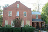 | September 20, 2006 (#06000845) | 1002 N. Pine St. 32°22′28″N 81°18′58″W / 32.3744°N 81.3160°W / 32.3744; -81.3160 (Effingham County Jail) | Springfield | Built in 1935 |
| 4 | Guyton Historic District |  | September 30, 1982 (#82002408) | Bounded by the city limits on the east, south, and west, and Alexander Ave. on the north 32°20′07″N 81°23′34″W / 32.3353°N 81.3928°W / 32.3353; -81.3928 (Guyton Historic District) | Guyton | |
| 5 | New Hope AME Church |  | March 13, 1986 (#86000364) | Alexander St. 32°20′32″N 81°23′30″W / 32.3421°N 81.3917°W / 32.3421; -81.3917 (New Hope AME Church) | Guyton | Built in 1885 |
| 6 | Reiser-Zoller Farm | 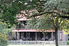 | March 2, 1989 (#89000152) | State Route 119, 4 miles north of Springfield 32°24′49″N 81°16′55″W / 32.4136°N 81.2819°W / 32.4136; -81.2819 (Reiser-Zoller Farm) | Springfield | Built in 1900, the farmhouse is down a private drive |
| 7 | Springfield Historic District | Upload image | April 2, 2021 (#100006329) | Roughly bounded by Railroad and 2nd Aves., Laberta Cir., Early, Cedar, 3rd and 4th Sts. 32°21′59″N 81°18′42″W / 32.3665°N 81.3116°W / 32.3665; -81.3116 (Springfield Historic District) | Springfield |
References
- ^ National Park Service, United States Department of the Interior, "National Register of Historic Places: Weekly List Actions", retrieved September 5, 2024.
- ^ Numbers represent an alphabetical ordering by significant words. Various colorings, defined here, differentiate National Historic Landmarks and historic districts from other NRHP buildings, structures, sites or objects.
- ^ The eight-digit number below each date is the number assigned to each location in the National Register Information System database, which can be viewed by clicking the number.
Wikimedia Commons has media related to National Register of Historic Places in Effingham County, Georgia.
| |
|---|---|
| Topics | |
| Lists by state |
|
| Lists by insular areas | |
| Lists by associated state | |
| Other areas | |
| Related | |
| |


