National Register of Historic Places listings in Taliaferro County, Georgia
This is a list of properties and districts in Taliaferro County, Georgia that are listed on the National Register of Historic Places (NRHP).
Map all coordinates using OpenStreetMap
Download coordinates as:
- KML
- GPX (all coordinates)
- GPX (primary coordinates)
- GPX (secondary coordinates)
This National Park Service list is complete through NPS recent listings posted September 5, 2024.[1]
- v
- t
- e
Properties on the National Register of Historic Places in Georgia by county
- Appling
- Atkinson
- Bacon
- Baker
- Baldwin
- Banks
- Barrow
- Bartow
- Ben Hill
- Berrien
- Bibb
- Bleckley
- Brantley
- Brooks
- Bryan
- Bulloch
- Burke
- Butts
- Calhoun
- Camden
- Candler
- Carroll
- Catoosa
- Charlton
- Chatham
- Chattahoochee
- Chattooga
- Cherokee
- Clarke
- Clay
- Clayton
- Clinch
- Cobb
- Coffee
- Colquitt
- Columbia
- Cook
- Coweta
- Crawford
- Crisp
- Dade
- Dawson
- Decatur
- DeKalb
- Dodge
- Dooly
- Dougherty
- Douglas
- Early
- Echols
- Effingham
- Elbert
- Emanuel
- Evans
- Fannin
- Fayette
- Floyd
- Forsyth
- Franklin
- Fulton
- Gilmer
- Glascock
- Glynn
- Gordon
- Grady
- Greene
- Gwinnett
- Habersham
- Hall
- Hancock
- Haralson
- Harris
- Hart
- Heard
- Henry
- Houston
- Irwin
- Jackson
- Jasper
- Jeff Davis
- Jefferson
- Jenkins
- Johnson
- Jones
- Lamar
- Lanier
- Laurens
- Lee
- Liberty
- Lincoln
- Long
- Lowndes
- Lumpkin
- Macon
- Madison
- Marion
- McDuffie
- McIntosh
- Meriwether
- Miller
- Mitchell
- Monroe
- Montgomery
- Morgan
- Murray
- Muscogee
- Newton
- Oconee
- Oglethorpe
- Paulding
- Peach
- Pickens
- Pierce
- Pike
- Polk
- Pulaski
- Putnam
- Quitman
- Rabun
- Randolph
- Richmond
- Rockdale
- Schley
- Screven
- Seminole
- Spalding
- Stephens
- Stewart
- Sumter
- Talbot
- Taliaferro
- Tattnall
- Taylor
- Telfair
- Terrell
- Thomas
- Tift
- Toombs
- Towns
- Treutlen
- Troup
- Turner
- Twiggs
- Union
- Upson
- Walker
- Walton
- Ware
- Warren
- Washington
- Wayne
- Webster
- Wheeler
- White
- Whitfield
- Wilcox
- Wilkes
- Wilkinson
- Worth

Current listings
| [2] | Name on the Register | Image | Date listed[3] | Location | City or town | Description |
|---|---|---|---|---|---|---|
| 1 | Chapman-Steed House | 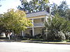 | October 22, 2002 (#02001218) | Broad St. 33°33′13″N 82°53′35″W / 33.553611°N 82.893056°W / 33.553611; -82.893056 (Chapman-Steed House) | Crawfordville | |
| 2 | Colonsay Plantation | Upload image | November 21, 1974 (#74000703) | ENE of Crawfordville off SR 908 33°35′57″N 82°41′51″W / 33.599167°N 82.6975°W / 33.599167; -82.6975 (Colonsay Plantation) | Crawfordville | |
| 3 | Crawfordville Historic District |  | March 14, 2006 (#06000124) | Roughly centered on the downtown business district of Crawfordville 33°33′30″N 82°48′10″W / 33.558333°N 82.802778°W / 33.558333; -82.802778 (Crawfordville Historic District) | Crawfordville | |
| 4 | Liberty Hall |  | May 13, 1970 (#70000216) | Alexander H. Stephens Memorial State Park 33°33′28″N 82°53′45″W / 33.557778°N 82.895833°W / 33.557778; -82.895833 (Liberty Hall) | Crawfordville | A National Historic Landmark and a Georgia state historic site |
| 5 | Locust Grove Cemetery |  | December 12, 2006 (#06001119) | Locust Grove Rd. SE 33°32′32″N 82°46′32″W / 33.542222°N 82.775556°W / 33.542222; -82.775556 (Locust Grove Cemetery) | Sharon | |
| 6 | A. H. Stephens Memorial State Park | 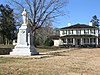 | June 22, 1995 (#95000764) | GA 22, N side 33°34′13″N 82°53′39″W / 33.570278°N 82.894167°W / 33.570278; -82.894167 (A. H. Stephens Memorial State Park) | Crawfordville | A Georgia state historic site |
| 7 | Taliaferro County Courthouse |  | September 18, 1980 (#80001242) | GA 12 33°33′16″N 82°53′48″W / 33.554444°N 82.896667°W / 33.554444; -82.896667 (Taliaferro County Courthouse) | Crawfordville |
References
- ^ National Park Service, United States Department of the Interior, "National Register of Historic Places: Weekly List Actions", retrieved September 5, 2024.
- ^ Numbers represent an alphabetical ordering by significant words. Various colorings, defined here, differentiate National Historic Landmarks and historic districts from other NRHP buildings, structures, sites or objects.
- ^ The eight-digit number below each date is the number assigned to each location in the National Register Information System database, which can be viewed by clicking the number.
Wikimedia Commons has media related to National Register of Historic Places in Taliaferro County, Georgia.


