National Register of Historic Places listings in Hancock County, Georgia
This is a list of properties and districts in Hancock County, Georgia that are listed on the National Register of Historic Places (NRHP).
Map all coordinates using OpenStreetMap
Download coordinates as:
- KML
- GPX (all coordinates)
- GPX (primary coordinates)
- GPX (secondary coordinates)
This National Park Service list is complete through NPS recent listings posted September 5, 2024.[1]
- v
- t
- e
Properties on the National Register of Historic Places in Georgia by county
- Appling
- Atkinson
- Bacon
- Baker
- Baldwin
- Banks
- Barrow
- Bartow
- Ben Hill
- Berrien
- Bibb
- Bleckley
- Brantley
- Brooks
- Bryan
- Bulloch
- Burke
- Butts
- Calhoun
- Camden
- Candler
- Carroll
- Catoosa
- Charlton
- Chatham
- Chattahoochee
- Chattooga
- Cherokee
- Clarke
- Clay
- Clayton
- Clinch
- Cobb
- Coffee
- Colquitt
- Columbia
- Cook
- Coweta
- Crawford
- Crisp
- Dade
- Dawson
- Decatur
- DeKalb
- Dodge
- Dooly
- Dougherty
- Douglas
- Early
- Echols
- Effingham
- Elbert
- Emanuel
- Evans
- Fannin
- Fayette
- Floyd
- Forsyth
- Franklin
- Fulton
- Gilmer
- Glascock
- Glynn
- Gordon
- Grady
- Greene
- Gwinnett
- Habersham
- Hall
- Hancock
- Haralson
- Harris
- Hart
- Heard
- Henry
- Houston
- Irwin
- Jackson
- Jasper
- Jeff Davis
- Jefferson
- Jenkins
- Johnson
- Jones
- Lamar
- Lanier
- Laurens
- Lee
- Liberty
- Lincoln
- Long
- Lowndes
- Lumpkin
- Macon
- Madison
- Marion
- McDuffie
- McIntosh
- Meriwether
- Miller
- Mitchell
- Monroe
- Montgomery
- Morgan
- Murray
- Muscogee
- Newton
- Oconee
- Oglethorpe
- Paulding
- Peach
- Pickens
- Pierce
- Pike
- Polk
- Pulaski
- Putnam
- Quitman
- Rabun
- Randolph
- Richmond
- Rockdale
- Schley
- Screven
- Seminole
- Spalding
- Stephens
- Stewart
- Sumter
- Talbot
- Taliaferro
- Tattnall
- Taylor
- Telfair
- Terrell
- Thomas
- Tift
- Toombs
- Towns
- Treutlen
- Troup
- Turner
- Twiggs
- Union
- Upson
- Walker
- Walton
- Ware
- Warren
- Washington
- Wayne
- Webster
- Wheeler
- White
- Whitfield
- Wilcox
- Wilkes
- Wilkinson
- Worth

Current listings
| [2] | Name on the Register | Image | Date listed[3] | Location | City or town | Description |
|---|---|---|---|---|---|---|
| 1 | Camilla-Zack Community Center District | Upload image | December 2, 1974 (#74000685) | Rte. 1 33°24′41″N 82°56′29″W / 33.411342°N 82.941309°W / 33.411342; -82.941309 (Camilla-Zack Community Center District) | Mayfield vic. | (article in draft--doncram) |
| 2 | Cheely-Coleman House |  | October 29, 1976 (#76000638) | S of Jewell off GA 123 at Ogeechee River 33°15′07″N 82°45′35″W / 33.251944°N 82.759722°W / 33.251944; -82.759722 (Cheely-Coleman House) | Jewell | |
| 3 | Glen Mary | Upload image | May 8, 1974 (#74000687) | Linton Rd., S of Sparta 33°10′40″N 83°00′06″W / 33.1778°N 83.0016°W / 33.1778; -83.0016 (Glen Mary) | Sparta | |
| 4 | Hurt-Rives Plantation | Upload image | August 8, 1996 (#96000874) | Off Rives Rd., northwest of Sparta[4] 33°18′34″N 83°07′08″W / 33.3094°N 83.1189°W / 33.3094; -83.1189 (Hurt-Rives Plantation) | Sparta | |
| 5 | John S. Jackson Plantation House and Outbuildings | Upload image | June 28, 1984 (#84001116) | Off GA 16 33°24′17″N 83°05′18″W / 33.404722°N 83.088333°W / 33.404722; -83.088333 (John S. Jackson Plantation House and Outbuildings) | White Plains | |
| 6 | Jewell Historic District |  | May 14, 1979 (#79003106) | GA 248 and GA 16 33°17′41″N 82°46′58″W / 33.294722°N 82.782778°W / 33.294722; -82.782778 (Jewell Historic District) | Jewell | |
| 7 | Linton Historic District |  | June 18, 1975 (#75000597) | Town of Linton and its environs 33°06′52″N 82°58′58″W / 33.114444°N 82.982778°W / 33.114444; -82.982778 (Linton Historic District) | Linton | |
| 8 | Pearson-Boyer Plantation | Upload image | April 12, 1993 (#93000236) | Pearson Chapel Rd. 33°11′06″N 83°01′00″W / 33.18489°N 83.01665°W / 33.18489; -83.01665 (Pearson-Boyer Plantation) | Sparta | |
| 9 | Rockby | Upload image | July 12, 1978 (#78000988) | NE of Sparta off GA 16 33°18′11″N 82°56′26″W / 33.303056°N 82.940556°W / 33.303056; -82.940556 (Rockby) | Sparta | |
| 10 | Shivers-Simpson House | Upload image | June 22, 1970 (#70000207) | N of Jewell on Mayfield Rd. 33°18′30″N 82°47′30″W / 33.308333°N 82.791667°W / 33.308333; -82.791667 (Shivers-Simpson House) | Jewell | |
| 11 | Sparta Cemetery | 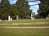 | June 22, 2001 (#01000647) | N of jct. of Hamilton and Boland Sts. 33°16′43″N 82°58′26″W / 33.278611°N 82.973889°W / 33.278611; -82.973889 (Sparta Cemetery) | Sparta | |
| 12 | Sparta Historic District | 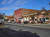 | April 16, 1974 (#74000686) | Roughly bounded by Hamilton, Elm, W, and Burwell Sts. 33°16′36″N 82°58′36″W / 33.276667°N 82.976667°W / 33.276667; -82.976667 (Sparta Historic District) | Sparta | The old courthouse is a contributing property that is in peril, see Georgia Trust. Includes the Rossiter-Little House |
References
- ^ National Park Service, United States Department of the Interior, "National Register of Historic Places: Weekly List Actions", retrieved September 5, 2024.
- ^ Numbers represent an alphabetical ordering by significant words. Various colorings, defined here, differentiate National Historic Landmarks and historic districts from other NRHP buildings, structures, sites or objects.
- ^ The eight-digit number below each date is the number assigned to each location in the National Register Information System database, which can be viewed by clicking the number.
- ^ Location derived from its coordinates; the NRIS provides coordinates but lists the property as "Address Restricted"
Wikimedia Commons has media related to National Register of Historic Places in Hancock County, Georgia.
| |
|---|---|
| Topics | |
| Lists by state |
|
| Lists by insular areas | |
| Lists by associated state | |
| Other areas | |
| Related | |
| |


