National Register of Historic Places listings in McDuffie County, Georgia
This is a list of properties and districts in McDuffie County, Georgia that are listed on the National Register of Historic Places (NRHP).
Map all coordinates using OpenStreetMap
Download coordinates as:
- KML
- GPX (all coordinates)
- GPX (primary coordinates)
- GPX (secondary coordinates)
This National Park Service list is complete through NPS recent listings posted September 5, 2024.[1]
- v
- t
- e
Properties on the National Register of Historic Places in Georgia by county
- Appling
- Atkinson
- Bacon
- Baker
- Baldwin
- Banks
- Barrow
- Bartow
- Ben Hill
- Berrien
- Bibb
- Bleckley
- Brantley
- Brooks
- Bryan
- Bulloch
- Burke
- Butts
- Calhoun
- Camden
- Candler
- Carroll
- Catoosa
- Charlton
- Chatham
- Chattahoochee
- Chattooga
- Cherokee
- Clarke
- Clay
- Clayton
- Clinch
- Cobb
- Coffee
- Colquitt
- Columbia
- Cook
- Coweta
- Crawford
- Crisp
- Dade
- Dawson
- Decatur
- DeKalb
- Dodge
- Dooly
- Dougherty
- Douglas
- Early
- Echols
- Effingham
- Elbert
- Emanuel
- Evans
- Fannin
- Fayette
- Floyd
- Forsyth
- Franklin
- Fulton
- Gilmer
- Glascock
- Glynn
- Gordon
- Grady
- Greene
- Gwinnett
- Habersham
- Hall
- Hancock
- Haralson
- Harris
- Hart
- Heard
- Henry
- Houston
- Irwin
- Jackson
- Jasper
- Jeff Davis
- Jefferson
- Jenkins
- Johnson
- Jones
- Lamar
- Lanier
- Laurens
- Lee
- Liberty
- Lincoln
- Long
- Lowndes
- Lumpkin
- Macon
- Madison
- Marion
- McDuffie
- McIntosh
- Meriwether
- Miller
- Mitchell
- Monroe
- Montgomery
- Morgan
- Murray
- Muscogee
- Newton
- Oconee
- Oglethorpe
- Paulding
- Peach
- Pickens
- Pierce
- Pike
- Polk
- Pulaski
- Putnam
- Quitman
- Rabun
- Randolph
- Richmond
- Rockdale
- Schley
- Screven
- Seminole
- Spalding
- Stephens
- Stewart
- Sumter
- Talbot
- Taliaferro
- Tattnall
- Taylor
- Telfair
- Terrell
- Thomas
- Tift
- Toombs
- Towns
- Treutlen
- Troup
- Turner
- Twiggs
- Union
- Upson
- Walker
- Walton
- Ware
- Warren
- Washington
- Wayne
- Webster
- Wheeler
- White
- Whitfield
- Wilcox
- Wilkes
- Wilkinson
- Worth

Current listings
| [2] | Name on the Register | Image | Date listed[3] | Location | City or town | Description |
|---|---|---|---|---|---|---|
| 1 | Boneville Historic District | Upload image | February 10, 2000 (#00000072) | Jct. of Boneville Rd. and the Georgia RR, approx. 5 mi. SE of Thomson 33°25′59″N 82°26′17″W / 33.433056°N 82.438056°W / 33.433056; -82.438056 (Boneville Historic District) | Boneville | |
| 2 | Bowdre-Rees-Knox House |  | January 19, 1979 (#79003109) | SW of Thomson on Old Wrightsboro Rd. 33°32′17″N 82°32′52″W / 33.538056°N 82.547778°W / 33.538056; -82.547778 (Bowdre-Rees-Knox House) | Thomson | |
| 3 | Thomas Carr District | Upload image | December 6, 1975 (#75002059) | N of Thomason near jct. of GA 150 and I-20 33°31′43″N 82°26′33″W / 33.528611°N 82.4425°W / 33.528611; -82.4425 (Thomas Carr District) | Thomson | |
| 4 | James L. Hardaway House |  | September 16, 1993 (#93000942) | Old Mesena Rd. W of Thomson 33°26′53″N 82°34′41″W / 33.448056°N 82.578056°W / 33.448056; -82.578056 (James L. Hardaway House) | Thomson | |
| 5 | Hayes Line Historic District | Upload image | February 18, 2000 (#00000106) | Jct. of Twin Oaks Rd. and GA 223 33°28′17″N 82°31′06″W / 33.4714°N 82.5184°W / 33.4714; -82.5184 (Hayes Line Historic District) | Thomson | |
| 6 | Hickory Hill | 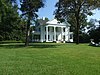 | November 15, 1979 (#79003110) | Hickory Hill Dr. and Lee St. 33°28′18″N 82°30′46″W / 33.471667°N 82.512778°W / 33.471667; -82.512778 (Hickory Hill) | Thomson | Includes the Thomas Watson house and other structures |
| 7 | Hillman-Bowden House | Upload image | November 1, 2002 (#02001259) | 1348 Pyland Crossing Rd. 33°26′31″N 82°33′23″W / 33.44193°N 82.55644°W / 33.44193; -82.55644 (Hillman-Bowden House) | Thomson | |
| 8 | John Moore Lazenby House |  | May 8, 2013 (#13000241) | 1353 Cedar Rock Rd. 33°29′04″N 82°31′36″W / 33.484556°N 82.526743°W / 33.484556; -82.526743 (John Moore Lazenby House) | Thomson vicinity | |
| 9 | McNeill House | Upload image | November 27, 1992 (#92001637) | 220 Lee St. 33°28′02″N 82°30′28″W / 33.46713°N 82.50776°W / 33.46713; -82.50776 (McNeill House) | Thomson | |
| 10 | Old Rock House |  | December 29, 1970 (#70000841) | NW of Thomson on Old Rock House Rd. 33°28′56″N 82°33′28″W / 33.48226°N 82.55784°W / 33.48226; -82.55784 (Old Rock House) | Thomson | The property is owned by McDuffee County as of 2020. It is the oldest well-documented house in Georgia.[4] |
| 11 | Pine Top Farm | Upload image | June 5, 1996 (#96000582) | Jct. of US 78 and US 278, 2 mi. E of Thomson 33°27′24″N 82°28′04″W / 33.456667°N 82.467778°W / 33.456667; -82.467778 (Pine Top Farm) | Thomson | |
| 12 | Sweetwater Inn | Upload image | May 2, 1985 (#85000938) | Off GA 17 on Old Milledgeville Rd. 33°24′58″N 82°27′19″W / 33.416111°N 82.455278°W / 33.416111; -82.455278 (Sweetwater Inn) | Thomson | |
| 13 | Thomson Commercial Historic District |  | June 9, 1989 (#89000413) | Roughly bounded by Journal St., Greenway St., Railroad St., Hendricks St., and Church St. 33°27′58″N 82°30′05″W / 33.466111°N 82.501389°W / 33.466111; -82.501389 (Thomson Commercial Historic District) | Thomson | |
| 14 | Usry House |  | October 1, 1974 (#74002182) | 211 Milledge St. 33°27′58″N 82°30′20″W / 33.466111°N 82.505556°W / 33.466111; -82.505556 (Usry House) | Thomson | |
| 15 | Thomas E. Watson House | | May 11, 1976 (#76002144) | 310 Lumpkin St. 33°28′12″N 82°30′30″W / 33.4699°N 82.50825°W / 33.4699; -82.50825 (Thomas E. Watson House) | Thomson | Home of Georgia Populist Party co-founder Thomas E. Watson, is a National Historic Landmark, Watson-Brown Foundation website. The house is part of Hickory Hill. |
| 16 | Wrightsboro Historic District | Upload image | July 6, 1998 (#98000701) | Wrightsboro Rd., E. of Ridge Rd. 33°33′00″N 82°34′09″W / 33.55°N 82.569167°W / 33.55; -82.569167 (Wrightsboro Historic District) | Wrightsboro |
References
Wikimedia Commons has media related to National Register of Historic Places in McDuffie County, Georgia.
- ^ National Park Service, United States Department of the Interior, "National Register of Historic Places: Weekly List Actions", retrieved September 5, 2024.
- ^ Numbers represent an alphabetical ordering by significant words. Various colorings, defined here, differentiate National Historic Landmarks and historic districts from other NRHP buildings, structures, sites or objects.
- ^ The eight-digit number below each date is the number assigned to each location in the National Register Information System database, which can be viewed by clicking the number.
- ^ Georgia Support Historic Preservation[usurped]


