National Register of Historic Places listings in Oglethorpe County, Georgia
This is a list of properties and districts in Oglethorpe County, Georgia that are listed on the National Register of Historic Places (NRHP).
Map all coordinates using OpenStreetMap
Download coordinates as:
- KML
- GPX (all coordinates)
- GPX (primary coordinates)
- GPX (secondary coordinates)
This National Park Service list is complete through NPS recent listings posted September 5, 2024.[1]
- v
- t
- e
Properties on the National Register of Historic Places in Georgia by county
- Appling
- Atkinson
- Bacon
- Baker
- Baldwin
- Banks
- Barrow
- Bartow
- Ben Hill
- Berrien
- Bibb
- Bleckley
- Brantley
- Brooks
- Bryan
- Bulloch
- Burke
- Butts
- Calhoun
- Camden
- Candler
- Carroll
- Catoosa
- Charlton
- Chatham
- Chattahoochee
- Chattooga
- Cherokee
- Clarke
- Clay
- Clayton
- Clinch
- Cobb
- Coffee
- Colquitt
- Columbia
- Cook
- Coweta
- Crawford
- Crisp
- Dade
- Dawson
- Decatur
- DeKalb
- Dodge
- Dooly
- Dougherty
- Douglas
- Early
- Echols
- Effingham
- Elbert
- Emanuel
- Evans
- Fannin
- Fayette
- Floyd
- Forsyth
- Franklin
- Fulton
- Gilmer
- Glascock
- Glynn
- Gordon
- Grady
- Greene
- Gwinnett
- Habersham
- Hall
- Hancock
- Haralson
- Harris
- Hart
- Heard
- Henry
- Houston
- Irwin
- Jackson
- Jasper
- Jeff Davis
- Jefferson
- Jenkins
- Johnson
- Jones
- Lamar
- Lanier
- Laurens
- Lee
- Liberty
- Lincoln
- Long
- Lowndes
- Lumpkin
- Macon
- Madison
- Marion
- McDuffie
- McIntosh
- Meriwether
- Miller
- Mitchell
- Monroe
- Montgomery
- Morgan
- Murray
- Muscogee
- Newton
- Oconee
- Oglethorpe
- Paulding
- Peach
- Pickens
- Pierce
- Pike
- Polk
- Pulaski
- Putnam
- Quitman
- Rabun
- Randolph
- Richmond
- Rockdale
- Schley
- Screven
- Seminole
- Spalding
- Stephens
- Stewart
- Sumter
- Talbot
- Taliaferro
- Tattnall
- Taylor
- Telfair
- Terrell
- Thomas
- Tift
- Toombs
- Towns
- Treutlen
- Troup
- Turner
- Twiggs
- Union
- Upson
- Walker
- Walton
- Ware
- Warren
- Washington
- Wayne
- Webster
- Wheeler
- White
- Whitfield
- Wilcox
- Wilkes
- Wilkinson
- Worth

Current listings
| [2] | Name on the Register | Image | Date listed[3] | Location | City or town | Description |
|---|---|---|---|---|---|---|
| 1 | Amis-Elder House |  | August 2, 1978 (#78000997) | W of Crawford on Elder Rd. 33°49′04″N 83°15′55″W / 33.817778°N 83.265278°W / 33.817778; -83.265278 (Amis-Elder House) | Crawford | |
| 2 | J. L. Bridges Home Place | Upload image | January 31, 1978 (#78000999) | N of Lexington on GA 22 33°56′04″N 83°01′28″W / 33.934444°N 83.024444°W / 33.934444; -83.024444 (J. L. Bridges Home Place) | Lexington | |
| 3 | Crawford Depot | 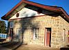 | May 27, 1977 (#77000441) | U.S. 78 33°52′57″N 83°09′22″W / 33.8825°N 83.156111°W / 33.8825; -83.156111 (Crawford Depot) | Crawford | |
| 4 | Durham Place |  | June 5, 2017 (#100001020) | 261 N. Main St. 33°45′24″N 83°10′28″W / 33.756745°N 83.174515°W / 33.756745; -83.174515 (Durham Place) | Maxeys | |
| 5 | Faust Houses and Outbuildings | Upload image | February 12, 1980 (#80001217) | NE of Lexington off GA 77 33°53′46″N 83°00′56″W / 33.896111°N 83.015556°W / 33.896111; -83.015556 (Faust Houses and Outbuildings) | Lexington | Buildings and house no longer exist |
| 6 | Howard's Covered Bridge | 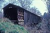 | July 1, 1975 (#75000604) | 3 mi. SE of Smithonia on SR S2164 over Big Clouds Creek 33°59′09″N 83°08′01″W / 33.985833°N 83.133611°W / 33.985833; -83.133611 (Howard's Covered Bridge) | Smithonia | |
| 7 | Langston-Daniel House |  | January 31, 1978 (#78000998) | 5 mi. (8 km) W of Crawford on U.S. 78 33°53′45″N 83°13′03″W / 33.895833°N 83.2175°W / 33.895833; -83.2175 (Langston-Daniel House) | Crawford | |
| 8 | Lexington Historic District |  | April 13, 1977 (#77000442) | U.S. 78 33°52′16″N 83°06′36″W / 33.871111°N 83.11°W / 33.871111; -83.11 (Lexington Historic District) | Lexington | |
| 9 | Maxeys Historic District | Upload image | September 2, 2022 (#100008047) | Area surrounding GA 77 (Main St. or Union Point Rd.) 33°45′17″N 83°10′26″W / 33.7546°N 83.1739°W / 33.7546; -83.1739 (Maxeys Historic District) | Maxeys | |
| 10 | Philomath Historic District | 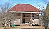 | July 6, 1979 (#79000740) | GA 22 33°43′19″N 82°59′01″W / 33.721944°N 82.983611°W / 33.721944; -82.983611 (Philomath Historic District) | Philomath | |
| 11 | Smith-Harris House | Upload image | July 25, 1985 (#85001620) | CR 207 33°56′57″N 82°57′41″W / 33.949167°N 82.961389°W / 33.949167; -82.961389 (Smith-Harris House) | Vesta | |
| 12 | Smithonia | 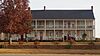 | June 21, 1984 (#84001213) | Address Restricted | Comer | |
| 12 | Watson Mill Covered Bridge and Mill Historic District |  | September 5, 1991 (#91001147) | Along S. Fork Broad R., Watson Mill State Park 34°01′34″N 83°04′23″W / 34.026111°N 83.073056°W / 34.026111; -83.073056 (Watson Mill Covered Bridge and Mill Historic District) | Comer |
References
Wikimedia Commons has media related to National Register of Historic Places in Oglethorpe County, Georgia.
- ^ National Park Service, United States Department of the Interior, "National Register of Historic Places: Weekly List Actions", retrieved September 5, 2024.
- ^ Numbers represent an alphabetical ordering by significant words. Various colorings, defined here, differentiate National Historic Landmarks and historic districts from other NRHP buildings, structures, sites or objects.
- ^ The eight-digit number below each date is the number assigned to each location in the National Register Information System database, which can be viewed by clicking the number.
| |
|---|---|
| Topics | |
| Lists by state |
|
| Lists by insular areas | |
| Lists by associated state | |
| Other areas | |
| Related | |
| |


