National Register of Historic Places listings in Glynn County, Georgia

This is a list of properties and districts in Glynn County, Georgia that are listed on the National Register of Historic Places (NRHP).
Map all coordinates using OpenStreetMap
Download coordinates as:
- KML
- GPX (all coordinates)
- GPX (primary coordinates)
- GPX (secondary coordinates)
This National Park Service list is complete through NPS recent listings posted September 5, 2024.[1]
- v
- t
- e
Properties on the National Register of Historic Places in Georgia by county
- Appling
- Atkinson
- Bacon
- Baker
- Baldwin
- Banks
- Barrow
- Bartow
- Ben Hill
- Berrien
- Bibb
- Bleckley
- Brantley
- Brooks
- Bryan
- Bulloch
- Burke
- Butts
- Calhoun
- Camden
- Candler
- Carroll
- Catoosa
- Charlton
- Chatham
- Chattahoochee
- Chattooga
- Cherokee
- Clarke
- Clay
- Clayton
- Clinch
- Cobb
- Coffee
- Colquitt
- Columbia
- Cook
- Coweta
- Crawford
- Crisp
- Dade
- Dawson
- Decatur
- DeKalb
- Dodge
- Dooly
- Dougherty
- Douglas
- Early
- Echols
- Effingham
- Elbert
- Emanuel
- Evans
- Fannin
- Fayette
- Floyd
- Forsyth
- Franklin
- Fulton
- Gilmer
- Glascock
- Glynn
- Gordon
- Grady
- Greene
- Gwinnett
- Habersham
- Hall
- Hancock
- Haralson
- Harris
- Hart
- Heard
- Henry
- Houston
- Irwin
- Jackson
- Jasper
- Jeff Davis
- Jefferson
- Jenkins
- Johnson
- Jones
- Lamar
- Lanier
- Laurens
- Lee
- Liberty
- Lincoln
- Long
- Lowndes
- Lumpkin
- Macon
- Madison
- Marion
- McDuffie
- McIntosh
- Meriwether
- Miller
- Mitchell
- Monroe
- Montgomery
- Morgan
- Murray
- Muscogee
- Newton
- Oconee
- Oglethorpe
- Paulding
- Peach
- Pickens
- Pierce
- Pike
- Polk
- Pulaski
- Putnam
- Quitman
- Rabun
- Randolph
- Richmond
- Rockdale
- Schley
- Screven
- Seminole
- Spalding
- Stephens
- Stewart
- Sumter
- Talbot
- Taliaferro
- Tattnall
- Taylor
- Telfair
- Terrell
- Thomas
- Tift
- Toombs
- Towns
- Treutlen
- Troup
- Turner
- Twiggs
- Union
- Upson
- Walker
- Walton
- Ware
- Warren
- Washington
- Wayne
- Webster
- Wheeler
- White
- Whitfield
- Wilcox
- Wilkes
- Wilkinson
- Worth

Current listings
| [2] | Name on the Register | Image | Date listed[3] | Location | City or town | Description |
|---|---|---|---|---|---|---|
| 1 | Ballard School | 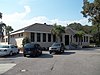 | October 27, 2004 (#04001181) | 323 Old Jesup Hwy. 31°12′17″N 81°30′22″W / 31.20460°N 81.50619°W / 31.20460; -81.50619 (Ballard School) | Brunswick | |
| 2 | Brunswick Old Town | 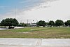 | December 2, 1974 (#74000683) | Address Restricted | Brunswick | An archeological area seven blocks long and three blocks wide along Bay Street, it was leveled in 1974 (from NRHP #79000727) |
| 3 | Brunswick Old Town Historic District |  | April 26, 1979 (#79000727) | Roughly bounded by 1st, Bay, New Bay, H and Cochran Sts. 31°08′43″N 81°29′29″W / 31.145278°N 81.491389°W / 31.145278; -81.491389 (Brunswick Old Town Historic District) | Brunswick | An area slightly larger than the original city plan |
| 4 | Colored Memorial School and Risley High School |  | November 7, 2002 (#02001290) | 1800 Albany St. 31°09′20″N 81°29′28″W / 31.15563°N 81.49100°W / 31.15563; -81.49100 (Colored Memorial School and Risley High School) | Brunswick | |
| 5 | Dixville Historic District | 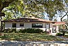 | December 9, 2019 (#100004744) | Bounded by rear property lines along Walnut Ave., Palmetto Ave. to Prince St., Martin Luther King Jr. Blvd. & Stonewall St. 31°08′45″N 81°29′06″W / 31.1459°N 81.4850°W / 31.1459; -81.4850 (Dixville Historic District) | Brunswick | |
| 6 | Faith Chapel | 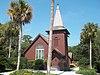 | July 14, 1971 (#71000277) | Old Plantation Rd. 31°03′38″N 81°25′18″W / 31.060556°N 81.421667°W / 31.060556; -81.421667 (Faith Chapel) | Jekyll Island | |
| 7 | Fort Frederica National Monument | 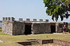 | October 15, 1966 (#66000065) | 12 mi. N of Brunswick 31°13′26″N 81°23′36″W / 31.22384°N 81.39324°W / 31.22384; -81.39324 (Fort Frederica National Monument) | St. Simons Island | administered by the National Park Service; boundary increase approved July 23, 2020 |
| 8 | Glynn Academy |  | November 4, 2011 (#11000775) | Southeast corner of Egmont and Monck Sts. 31°08′55″N 81°29′26″W / 31.14864°N 81.49062°W / 31.14864; -81.49062 (Glynn Academy) | Brunswick | Apparently the 1840 Glynn Acad. Building is on the NRHP itself, while three buildings are contributing properties to Brunswick Old Town HD |
| 9 | Hamilton Plantation slave cabins | 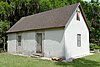 | June 30, 1988 (#88000968) | Address Restricted (on Gascoigne Bluff, 100 Arthur J. Moore Drive) 31°10′16″N 81°24′28″W / 31.17106°N 81.40771°W / 31.17106; -81.40771 (Hamilton Plantation slave cabins) | St. Simons Island | Two unusually well-built slave cabins (a duplex), built before 1833; summer tours given by Cassina Garden Club |
| 10 | Hofwyl-Broadfield Plantation |  | July 12, 1976 (#76000635) | N of Brunswick at 5556 U.S. Highway 17 North 31°18′18″N 81°27′13″W / 31.30500°N 81.45366°W / 31.30500; -81.45366 (Hofwyl-Broadfield Plantation) | Brunswick | Rice plantation from 1800 to 1915, the main house was built in the early 1850s. Now a Georgia state historic site. |
| 11 | Horton-duBignon House, Brewery Ruins, duBignon Cemetery |  | September 28, 1971 (#71000278) | Riverview Dr. 31°06′06″N 81°24′52″W / 31.10177°N 81.41456°W / 31.10177; -81.41456 (Horton-duBignon House, Brewery Ruins, duBignon Cemetery) | Jekyll Island | May be known as Horton House |
| 12 | Jekyll Island Historic District | 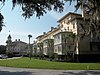 | January 20, 1972 (#72000385) | Between Riverview Dr. and Old Village Blvd. 31°03′34″N 81°25′20″W / 31.059444°N 81.422222°W / 31.059444; -81.422222 (Jekyll Island Historic District) | Jekyll Island | Ths historic district is a National Historic Landmark. |
| 13 | King and Prince Hotel |  | January 12, 2005 (#04001465) | 201 Arnold Rd. 31°08′21″N 81°22′44″W / 31.13921°N 81.37902°W / 31.13921; -81.37902 (King and Prince Hotel) | St. Simons Island | |
| 14 | Needwood Baptist Church and School | 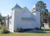 | December 17, 1998 (#98001520) | US 17, 1 mi. S of Hofwyl-Broadfield Plantation State Historic Site. 31°16′55″N 81°26′27″W / 31.28207°N 81.44079°W / 31.28207; -81.44079 (Needwood Baptist Church and School) | Brunswick | |
| 15 | Rockefeller Cottage | 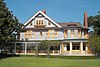 | July 14, 1971 (#71000279) | 331 Riverview Dr. 31°03′27″N 81°25′19″W / 31.0575°N 81.421944°W / 31.0575; -81.421944 (Rockefeller Cottage) | Jekyll Island | Also known as Indian Mound Cottage |
| 16 | St. Simons Lighthouse and Lighthouse Keepers' Building | 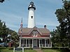 | April 13, 1972 (#72000386) | 600 Beachview Dr. 31°08′03″N 81°23′37″W / 31.13411°N 81.39357°W / 31.13411; -81.39357 (St. Simons Lighthouse and Lighthouse Keepers' Building) | St. Simons Island | |
| 17 | Strachan House Garage |  | July 3, 1997 (#97000660) | 414½ Butler Ave. 31°08′07″N 81°23′53″W / 31.135278°N 81.398056°W / 31.135278; -81.398056 (Strachan House Garage) | St. Simons Island | Two-story garage and residence built in 1925, formerly associated with an estate that no longer exists, converted to a residence-only. |
| 18 | US Coast Guard Station-St. Simons Island |  | April 1, 1998 (#98000297) | 4201 First St. 31°08′44″N 81°22′23″W / 31.14562°N 81.37316°W / 31.14562; -81.37316 (US Coast Guard Station-St. Simons Island) | St. Simons Island | Now houses the World War II Homefront Museum |
| 19 | United States Post Office and Court House | 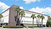 | April 15, 2014 (#14000153) | 805 Gloucester 31°09′01″N 81°29′33″W / 31.150240°N 81.492427°W / 31.150240; -81.492427 (United States Post Office and Court House) | Brunswick | Frank M. Scarlett Federal Building houses the Post Office and Federal Court |
| 20 | Windsor Park Historic District |  | November 29, 2013 (#13000877) | Bounded by Lanier Blvd., Walnut Ave., Gloucester & Magnolia Sts. 31°08′57″N 81°28′56″W / 31.149081°N 81.482334°W / 31.149081; -81.482334 (Windsor Park Historic District) | Brunswick |
References
- ^ National Park Service, United States Department of the Interior, "National Register of Historic Places: Weekly List Actions", retrieved September 5, 2024.
- ^ Numbers represent an alphabetical ordering by significant words. Various colorings, defined here, differentiate National Historic Landmarks and historic districts from other NRHP buildings, structures, sites or objects.
- ^ The eight-digit number below each date is the number assigned to each location in the National Register Information System database, which can be viewed by clicking the number.
Wikimedia Commons has media related to National Register of Historic Places in Glynn County, Georgia.
| |
|---|---|
| Topics | |
| Lists by state |
|
| Lists by insular areas | |
| Lists by associated state | |
| Other areas | |
| Related | |
| |


