National Register of Historic Places listings in Murray County, Georgia
This is a list of properties and districts in Murray County, Georgia that are listed on the National Register of Historic Places (NRHP).
Map all coordinates using OpenStreetMap
Download coordinates as:
- KML
- GPX (all coordinates)
- GPX (primary coordinates)
- GPX (secondary coordinates)
This National Park Service list is complete through NPS recent listings posted September 5, 2024.[1]
- v
- t
- e
Properties on the National Register of Historic Places in Georgia by county
- Appling
- Atkinson
- Bacon
- Baker
- Baldwin
- Banks
- Barrow
- Bartow
- Ben Hill
- Berrien
- Bibb
- Bleckley
- Brantley
- Brooks
- Bryan
- Bulloch
- Burke
- Butts
- Calhoun
- Camden
- Candler
- Carroll
- Catoosa
- Charlton
- Chatham
- Chattahoochee
- Chattooga
- Cherokee
- Clarke
- Clay
- Clayton
- Clinch
- Cobb
- Coffee
- Colquitt
- Columbia
- Cook
- Coweta
- Crawford
- Crisp
- Dade
- Dawson
- Decatur
- DeKalb
- Dodge
- Dooly
- Dougherty
- Douglas
- Early
- Echols
- Effingham
- Elbert
- Emanuel
- Evans
- Fannin
- Fayette
- Floyd
- Forsyth
- Franklin
- Fulton
- Gilmer
- Glascock
- Glynn
- Gordon
- Grady
- Greene
- Gwinnett
- Habersham
- Hall
- Hancock
- Haralson
- Harris
- Hart
- Heard
- Henry
- Houston
- Irwin
- Jackson
- Jasper
- Jeff Davis
- Jefferson
- Jenkins
- Johnson
- Jones
- Lamar
- Lanier
- Laurens
- Lee
- Liberty
- Lincoln
- Long
- Lowndes
- Lumpkin
- Macon
- Madison
- Marion
- McDuffie
- McIntosh
- Meriwether
- Miller
- Mitchell
- Monroe
- Montgomery
- Morgan
- Murray
- Muscogee
- Newton
- Oconee
- Oglethorpe
- Paulding
- Peach
- Pickens
- Pierce
- Pike
- Polk
- Pulaski
- Putnam
- Quitman
- Rabun
- Randolph
- Richmond
- Rockdale
- Schley
- Screven
- Seminole
- Spalding
- Stephens
- Stewart
- Sumter
- Talbot
- Taliaferro
- Tattnall
- Taylor
- Telfair
- Terrell
- Thomas
- Tift
- Toombs
- Towns
- Treutlen
- Troup
- Turner
- Twiggs
- Union
- Upson
- Walker
- Walton
- Ware
- Warren
- Washington
- Wayne
- Webster
- Wheeler
- White
- Whitfield
- Wilcox
- Wilkes
- Wilkinson
- Worth

Current listings
| [2] | Name on the Register | Image | Date listed[3] | Location | City or town | Description |
|---|---|---|---|---|---|---|
| 1 | Carter's Quarters | Upload image | March 17, 1986 (#86000460) | Old U.S. Route 411, 9 miles south of Chatsworth 34°39′27″N 84°42′47″W / 34.6575°N 84.713056°W / 34.6575; -84.713056 (Carter's Quarters) | Chatsworth | |
| 2 | Chatsworth Downtown Historic District |  | July 13, 2005 (#05000693) | Roughly bounded by Peachtree St., 1st Ave., CSX railroad tracks, Fort St., and 4th Ave. 34°46′04″N 84°46′06″W / 34.767778°N 84.768333°W / 34.767778; -84.768333 (Chatsworth Downtown Historic District) | Chatsworth | |
| 3 | Fort Mountain |  | November 23, 1977 (#77001587) | U.S. Route 76 34°47′03″N 84°42′24″W / 34.784167°N 84.706667°W / 34.784167; -84.706667 (Fort Mountain) | Chatsworth | |
| 4 | Murray County Courthouse |  | September 18, 1980 (#80001123) | Courthouse Sq. 34°46′01″N 84°46′14″W / 34.766944°N 84.770556°W / 34.766944; -84.770556 (Murray County Courthouse) | Chatsworth | |
| 5 | Murray County High School Historic District | 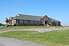 | June 21, 2004 (#04000628) | 1004 Green St. 34°46′37″N 84°47′20″W / 34.776944°N 84.788889°W / 34.776944; -84.788889 (Murray County High School Historic District) | Chatsworth | |
| 6 | Pleasant Valley Historic District | 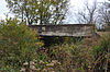 | September 24, 2009 (#09000751) | Roughly bounded by the CSX railroad line, the old city limits, and land lot lines 34°50′55″N 84°44′56″W / 34.848611°N 84.748889°W / 34.848611; -84.748889 (Pleasant Valley Historic District) | Crandall | |
| 7 | Spring Place Historic District | Upload image | January 4, 2005 (#04000338) | Approximately 2.5 miles west of Chatsworth, east of the junction of State Routes 52A and 225 34°46′22″N 84°54′42″W / 34.772778°N 84.911667°W / 34.772778; -84.911667 (Spring Place Historic District) | Spring Place | |
| 8 | Vann House |  | October 28, 1969 (#69000044) | Junction of U.S. Route 76 and State Route 225 34°45′50″N 84°50′35″W / 34.763889°N 84.843056°W / 34.763889; -84.843056 (Vann House) | Spring Place | A Georgia state historic site |
| 9 | Wright Hotel |  | June 17, 1982 (#82002456) | 201 E. Market St. 34°46′03″N 84°46′06″W / 34.7675°N 84.768333°W / 34.7675; -84.768333 (Wright Hotel) | Chatsworth |
References
Wikimedia Commons has media related to National Register of Historic Places in Murray County, Georgia.
- ^ National Park Service, United States Department of the Interior, "National Register of Historic Places: Weekly List Actions", retrieved September 5, 2024.
- ^ Numbers represent an alphabetical ordering by significant words. Various colorings, defined here, differentiate National Historic Landmarks and historic districts from other NRHP buildings, structures, sites or objects.
- ^ The eight-digit number below each date is the number assigned to each location in the National Register Information System database, which can be viewed by clicking the number.


