National Register of Historic Places listings in Grady County, Georgia
This is a list of properties and districts in Grady County, Georgia that are listed on the National Register of Historic Places (NRHP).
Map all coordinates using OpenStreetMap
Download coordinates as:
- KML
- GPX (all coordinates)
- GPX (primary coordinates)
- GPX (secondary coordinates)
This National Park Service list is complete through NPS recent listings posted September 5, 2024.[1]
- v
- t
- e
Properties on the National Register of Historic Places in Georgia by county
- Appling
- Atkinson
- Bacon
- Baker
- Baldwin
- Banks
- Barrow
- Bartow
- Ben Hill
- Berrien
- Bibb
- Bleckley
- Brantley
- Brooks
- Bryan
- Bulloch
- Burke
- Butts
- Calhoun
- Camden
- Candler
- Carroll
- Catoosa
- Charlton
- Chatham
- Chattahoochee
- Chattooga
- Cherokee
- Clarke
- Clay
- Clayton
- Clinch
- Cobb
- Coffee
- Colquitt
- Columbia
- Cook
- Coweta
- Crawford
- Crisp
- Dade
- Dawson
- Decatur
- DeKalb
- Dodge
- Dooly
- Dougherty
- Douglas
- Early
- Echols
- Effingham
- Elbert
- Emanuel
- Evans
- Fannin
- Fayette
- Floyd
- Forsyth
- Franklin
- Fulton
- Gilmer
- Glascock
- Glynn
- Gordon
- Grady
- Greene
- Gwinnett
- Habersham
- Hall
- Hancock
- Haralson
- Harris
- Hart
- Heard
- Henry
- Houston
- Irwin
- Jackson
- Jasper
- Jeff Davis
- Jefferson
- Jenkins
- Johnson
- Jones
- Lamar
- Lanier
- Laurens
- Lee
- Liberty
- Lincoln
- Long
- Lowndes
- Lumpkin
- Macon
- Madison
- Marion
- McDuffie
- McIntosh
- Meriwether
- Miller
- Mitchell
- Monroe
- Montgomery
- Morgan
- Murray
- Muscogee
- Newton
- Oconee
- Oglethorpe
- Paulding
- Peach
- Pickens
- Pierce
- Pike
- Polk
- Pulaski
- Putnam
- Quitman
- Rabun
- Randolph
- Richmond
- Rockdale
- Schley
- Screven
- Seminole
- Spalding
- Stephens
- Stewart
- Sumter
- Talbot
- Taliaferro
- Tattnall
- Taylor
- Telfair
- Terrell
- Thomas
- Tift
- Toombs
- Towns
- Treutlen
- Troup
- Turner
- Twiggs
- Union
- Upson
- Walker
- Walton
- Ware
- Warren
- Washington
- Wayne
- Webster
- Wheeler
- White
- Whitfield
- Wilcox
- Wilkes
- Wilkinson
- Worth

Current listings
| [2] | Name on the Register | Image | Date listed[3] | Location | City or town | Description |
|---|---|---|---|---|---|---|
| 1 | Cairo Commercial Historic District |  | May 26, 1994 (#94000525) | Roughly bounded by Broad St., Railroad Ave. and Martin Luther King Ave., with adjacent properties on 2nd Ave. and 1st St 30°52′37″N 84°12′32″W / 30.876944°N 84.208889°W / 30.876944; -84.208889 (Cairo Commercial Historic District) | Cairo | Former Belk, Broad Ave. |
| 2 | Dickey-Birdsong Plantation |  | June 20, 1995 (#95000741) | Meridian Rd., off State Route 93 west of Beachton 30°42′11″N 84°11′35″W / 30.70306°N 84.19314°W / 30.70306; -84.19314 (Dickey-Birdsong Plantation) | Beachton | Now Birdsong Nature Center on Birdsong Rd |
| 3 | Ebenezer African Methodist Episcopal Church and School |  | July 23, 2008 (#08000714) | 232 Martin Ave. 30°53′05″N 84°19′46″W / 30.8847°N 84.32938°W / 30.8847; -84.32938 (Ebenezer African Methodist Episcopal Church and School) | Whigham | |
| 4 | Evergreen Congregational Church and School | 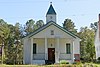 | October 31, 2002 (#02001260) | 497 Meridian Rd. 30°43′42″N 84°08′13″W / 30.72837°N 84.137°W / 30.72837; -84.137 (Evergreen Congregational Church and School) | Beachton | |
| 5 | Ochlocknee Missionary Baptist Church and Cemetery |  | November 17, 2010 (#10000924) | 521 U.S. Route 319 S. 30°45′26″N 84°05′33″W / 30.757222°N 84.092500°W / 30.757222; -84.092500 (Ochlocknee Missionary Baptist Church and Cemetery) | Beachton | |
| 6 | Pebble Hill Plantation |  | February 23, 1990 (#90000146) | U.S. Route 319, 4 miles southwest of Thomasville 30°46′49″N 84°03′50″W / 30.78022°N 84.06386°W / 30.78022; -84.06386 (Pebble Hill Plantation) | Thomasville | |
| 7 | Pope's Museum | Upload image | April 20, 2022 (#100007625) | 192 Pope's Store Rd. 30°58′59″N 84°09′39″W / 30.9831°N 84.1607°W / 30.9831; -84.1607 (Pope's Museum) | Ochlocknee | |
| 8 | Sasser Farm | Upload image | September 8, 1983 (#83000230) | Sasser Farm Rd. south of Cairo 30°47′11″N 84°14′20″W / 30.786389°N 84.238889°W / 30.786389; -84.238889 (Sasser Farm) | Cairo | |
| 9 | Susina Plantation | 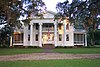 | August 12, 1970 (#70000205) | West of Beachton on Meridian Rd. 30°43′16″N 84°10′06″W / 30.7211°N 84.16846°W / 30.7211; -84.16846 (Susina Plantation) | Beachton |
References
- ^ National Park Service, United States Department of the Interior, "National Register of Historic Places: Weekly List Actions", retrieved September 5, 2024.
- ^ Numbers represent an alphabetical ordering by significant words. Various colorings, defined here, differentiate National Historic Landmarks and historic districts from other NRHP buildings, structures, sites or objects.
- ^ The eight-digit number below each date is the number assigned to each location in the National Register Information System database, which can be viewed by clicking the number.
Wikimedia Commons has media related to National Register of Historic Places in Grady County, Georgia.
| |
|---|---|
| Topics | |
| Lists by state |
|
| Lists by insular areas | |
| Lists by associated state | |
| Other areas | |
| Related | |
| |


