National Register of Historic Places listings in Union County, Georgia
This is a list of properties and districts in Union County, Georgia that are listed on the National Register of Historic Places (NRHP).
Map all coordinates using OpenStreetMap
Download coordinates as:
- KML
- GPX (all coordinates)
- GPX (primary coordinates)
- GPX (secondary coordinates)
This National Park Service list is complete through NPS recent listings posted September 5, 2024.[1]
- v
- t
- e
Properties on the National Register of Historic Places in Georgia by county
- Appling
- Atkinson
- Bacon
- Baker
- Baldwin
- Banks
- Barrow
- Bartow
- Ben Hill
- Berrien
- Bibb
- Bleckley
- Brantley
- Brooks
- Bryan
- Bulloch
- Burke
- Butts
- Calhoun
- Camden
- Candler
- Carroll
- Catoosa
- Charlton
- Chatham
- Chattahoochee
- Chattooga
- Cherokee
- Clarke
- Clay
- Clayton
- Clinch
- Cobb
- Coffee
- Colquitt
- Columbia
- Cook
- Coweta
- Crawford
- Crisp
- Dade
- Dawson
- Decatur
- DeKalb
- Dodge
- Dooly
- Dougherty
- Douglas
- Early
- Echols
- Effingham
- Elbert
- Emanuel
- Evans
- Fannin
- Fayette
- Floyd
- Forsyth
- Franklin
- Fulton
- Gilmer
- Glascock
- Glynn
- Gordon
- Grady
- Greene
- Gwinnett
- Habersham
- Hall
- Hancock
- Haralson
- Harris
- Hart
- Heard
- Henry
- Houston
- Irwin
- Jackson
- Jasper
- Jeff Davis
- Jefferson
- Jenkins
- Johnson
- Jones
- Lamar
- Lanier
- Laurens
- Lee
- Liberty
- Lincoln
- Long
- Lowndes
- Lumpkin
- Macon
- Madison
- Marion
- McDuffie
- McIntosh
- Meriwether
- Miller
- Mitchell
- Monroe
- Montgomery
- Morgan
- Murray
- Muscogee
- Newton
- Oconee
- Oglethorpe
- Paulding
- Peach
- Pickens
- Pierce
- Pike
- Polk
- Pulaski
- Putnam
- Quitman
- Rabun
- Randolph
- Richmond
- Rockdale
- Schley
- Screven
- Seminole
- Spalding
- Stephens
- Stewart
- Sumter
- Talbot
- Taliaferro
- Tattnall
- Taylor
- Telfair
- Terrell
- Thomas
- Tift
- Toombs
- Towns
- Treutlen
- Troup
- Turner
- Twiggs
- Union
- Upson
- Walker
- Walton
- Ware
- Warren
- Washington
- Wayne
- Webster
- Wheeler
- White
- Whitfield
- Wilcox
- Wilkes
- Wilkinson
- Worth

Current listings
| [2] | Name on the Register | Image | Date listed[3] | Location | City or town | Description |
|---|---|---|---|---|---|---|
| 1 | Nottely Hydroelectric Project |  | August 11, 2017 (#100001455) | Nottely Dam Rd. 34°57′33″N 84°05′21″W / 34.959148°N 84.089172°W / 34.959148; -84.089172 (Nottely Hydroelectric Project) | Blairsville | |
| 2 | Old Union County Courthouse | 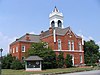 | September 18, 1980 (#80001249) | Courthouse Sq. 34°52′34″N 83°57′31″W / 34.87611°N 83.95850°W / 34.87611; -83.95850 (Old Union County Courthouse) | Blairsville | |
| 3 | Raburn-Casteel House | 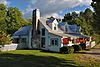 | October 26, 2001 (#01001181) | US 129, 4 mi. N. of Blairsville 34°54′29″N 84°00′36″W / 34.908056°N 84.01°W / 34.908056; -84.01 (Raburn-Casteel House) | Blairsville | |
| 4 | Union County Jail | 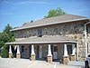 | September 13, 1985 (#85002088) | Blue Ridge Rd. 34°52′33″N 83°57′36″W / 34.875833°N 83.96°W / 34.875833; -83.96 (Union County Jail) | Blairsville | |
| 5 | Walasi-Yi Inn | 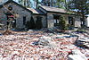 | January 12, 1979 (#79000749) | S. of Blairsville on U.S. 129 at Neels Gap 34°44′06″N 83°55′03″W / 34.735°N 83.9175°W / 34.735; -83.9175 (Walasi-Yi Inn) | Blairsville |
References
- ^ National Park Service, United States Department of the Interior, "National Register of Historic Places: Weekly List Actions", retrieved September 5, 2024.
- ^ Numbers represent an alphabetical ordering by significant words. Various colorings, defined here, differentiate National Historic Landmarks and historic districts from other NRHP buildings, structures, sites or objects.
- ^ The eight-digit number below each date is the number assigned to each location in the National Register Information System database, which can be viewed by clicking the number.
Wikimedia Commons has media related to National Register of Historic Places in Union County, Georgia.
| |
|---|---|
| Topics | |
| Lists by state |
|
| Lists by insular areas | |
| Lists by associated state | |
| Other areas | |
| Related | |
| |


